Jacksonville, Florida is a large city with a lot of people who love the outdoors. The area offshore from its beaches is also loaded with great fishing and diving spots. See this listing for some of the best Jacksonville dive sites with GPS coordinate numbers and location information.
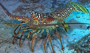
Explore natural live bottom ledges and purpose sunk artificial reefs. The wide variety of marine habitat allows for a plentiful bounty of fish species, pelagic fishes, lobsters and other sea life.
Jacksonville Dive Sites – GPS Coordinates
The listing showcases some of the best diving locations in this area, along with latitude and longitude coordinates, and location numbers.
These are assembled from public sources. So, when you locate the structure, fine-tune your waypoints based upon your GPS plotter.
Acosta Bridge Rubble
This is the rubble that once stood over the St. John’s River. It was sunk offshore in 1992. Some people also refer to this dive site as ‘Busey’s Bonanza’.
30° 25.62’N, 81° 08.531’W
Depth: ~ 65 – 75ft
Amberjack Hole
(Tug Monachan, Barge, Culverts and Concrete Boxes)
30° 32.81’N – 81° 03.16’W
Depth: ~75 – 80ft
Anna is a 225 foot freighter, purpose sunk in 1986. The Jacksonville Reef Research Team was instrumental in getting this ship purpose sunk as artificial marine habitat.
30° 27.81’N, 80° 55.975’W
Depth: ~ 95 – 110ft
Blackmar’s Reef
This popular dive site area contains several different purpose sunk ship wrecks including the ‘Super’, ‘Ocean Going Tug’ and the ‘Warwick’.
30° 21.761’N, 80° 50.03’W
30° 21. 733’N, 80° 49.969’W
Depth: ~ 95 – 105ft
Casablanca Wreck – 350′ Ship
30° 17.508’N, 80° 49.317’W
30° 17.482’N, 80° 49.43’W
Depth: ~ 100 – 115ft
Clayton’s Holler
30° 18.690’N, 81° 04.11’W
Depth: ~ 75ft
Coppedge Tug Boat
Lat/Lon: 30° 17.362’N, 80° 57.888’W
Depth” ~ 60 – 80ft
East Fourteen / Gator Bowl Reefs
This bottom area has several different reefs and ledges to explore. The area includes the debris from the Gator Bowl Stadium that was purpose sunk as an artificial reef. One of the big attractors to this bottom structure are the ‘press boxes’ from the stadium. They provide abundant habitat for reef dwelling sea animals and fish species.
30° 23.402’N, 81° 04.921’W
Depth: ~ 75-85ft
Press Boxes Artificial Reef
30° 23.852’N, 81° 03.565’W
30° 23.842’N, 81° 03.333’W
Depth: ~ 80ft
Ledge Reef – Live Bottom
30° 23.855’N, 81° 03.932’W
Depth: ~ 80ft
Gulf America Ship Wreck
Lat/Lon Coordinates: 30° 16.672’N, 81° 13.63’W
Depth: ~ 60ft
Hudgins – 150-foot Freighter
Lat/Lon: 30° 22.368’N, 80° 53.965’W
Depth: ~ 90 – 100ft
Montgomery’s Reef
Lat/Lon: 30° 26.79’N, 81° 13.200’W
Depth: ~ 60 – 65ft
Natural Ledges – Live Bottom Structure
Here are two natural bottom areas to explore. They are in close proximity to one another.
Lat/Lon: 30° 20.98’N, 81° 10.962’W
30° 20.629’N, 81° 11.410’W
Depth: ~ 70ft
Nine Mile Reef
This area contains a variety of ship wrecks, including the Asphalt Barge, Vic’s Barge, fishing boat, and a steamer tug.
30° 23.541’N, 81° 10.18’W
Asphalt Barge: 30° 23.534’N, 81° 10.264’W
Depth: ~ 65 – 75ft
Paul Mains Reef – Steel Barge
Lat/Lon: 30° 20.321’N, 81° 11.79’W
30° 19.861’N, 81° 11.02’W
Depth: ~ 65-70ft
Banana Pogey Boats – Steel Vessels
Lat/Lon: 30° 20.21’N, 81° 11.152’W
Depth: ~ 70ft
Rabbit’s Lair
30° 31.45’N, 81° 10.35’W
Depth:~ 65 – 70ft
These are certainly representative of the best Jacksonville dive sites. The waypoints listed here is only a small number of possibilities available to you.
Many of the dive sites listed, are really areas of congregated purpose sunk wrecks consisting of ships, boats, airplanes, concrete pipes and other reef materials.
As you find your favorite areas, map out a series of latitude and longitude GPS waypoints for your special places.
Discover and explore the tremendous marine life that these natural ledges and artificial reef habitats support.

